The City of Philadelphia today released a batch of datasets for Philadelphia’s streams and political districts. The data is from the Water Department and Planning Commission, and is geospatial (map-based). All of these datasets are now available for public consumption through Philadelphia’s open data community portal, Open Data Philly.
Here’s a look at the release:
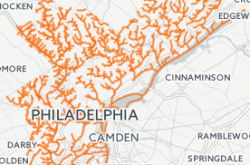
Water Department:
Historic Philadelphia streams, available both as Polygon and Line, mapped by Charles Ellet in 1842 combined with a study of these streams conducted by the Water Department.
Planning Commission:
- State House Representative Districts: Boundaries for Philadelphia State House Representative Districts for 2000 and 2012.
- State Senate Districts: Boundaries for Philadelphia State Senate Districts dating back for 2000 and 2012.
- United States Congressional Districts: Boundaries for Philadelphia United States Congressional Districts, for 2000 and 2012.
Keep in Touch!
There’s lots of ways to get involved. For information about these datasets and others, go to OpenDataPhilly.org. Visit this resources page for video tutorials and links to tools to help analyze data. Follow @PhilaGovData on Twitter to get alerts on future data releases, share how you plan to use open data with data@phila.gov, and join us on the public open data google forum.